Post by Marsrocks on Dec 26, 2011 9:46:49 GMT -5
Scientists overlay the mini-tes data on the pancam images to determine where certain materials are.
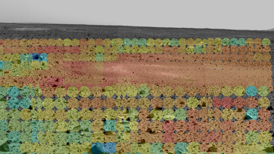
"Thar be Hematite!
This map of a portion of the small crater currently encircling the Mars Exploration Rover Opportunity shows where crystalline hematite resides. Red and orange patches indicate high levels of the iron-bearing mineral, while blue and green denote low levels. The northeastern rock outcropping lining the rim of the crater does not appear to contain much hematite. Also lacking hematite are the rover's airbag bounce marks. This image consists of data from Opportunity's miniature thermal emission spectrometer superimposed on an image taken by the rover's panoramic camera. "
marsrovers.jpl.nasa.gov/gallery/press/opportunity/20040204a.html

"Geologists were eager to reach a hematite-rich area (in the center of the picture at right) to closely examine the soil, which may reveal secrets about how the hematite got to this location. Knowing how the hematite on Mars was formed may help scientists characterize the past environment and determine whether that environment provided favorable conditions for life.
"Grey hematite is a mineral indicator of past water," said Dr. Joy Crisp, JPL project scientist. "It is not always associated with water, but it often is."
Scientists have wanted to find out which of these processes created grey hematite on Mars since 1998, when Mars Global Surveyor spotted large concentrations of the mineral near the planet's equator (seen in the left picture). This discovery provided the first mineral evidence that Mars' history may have included water.
"We want to know if the grains of hematite appear to be rounded and cemented together by the action of liquid water or if they're crystals that grew from a volcanic melt," said Crisp. "Is the hematite in layers, which would suggest that it was laid down by water, or in veins in the rock, which would be more characteristic of water having flowed through the rocks."
The next picture shows a mineral map, the first ever made on the surface of another planet, which was generated from a section of the panorama picture overlaid with data taken from the rover's Mini-TES. The Mini-TES spectral data was analyzed in a way that the concentration of the mineral hematite was deduced and its level coded in color. Red and orange mean high concentration, green and blue low concentration."
en.wikipedia.org/wiki/Scientific_information_from_the_Mars_Exploration_Rover_mission
"Thar be Hematite!
This map of a portion of the small crater currently encircling the Mars Exploration Rover Opportunity shows where crystalline hematite resides. Red and orange patches indicate high levels of the iron-bearing mineral, while blue and green denote low levels. The northeastern rock outcropping lining the rim of the crater does not appear to contain much hematite. Also lacking hematite are the rover's airbag bounce marks. This image consists of data from Opportunity's miniature thermal emission spectrometer superimposed on an image taken by the rover's panoramic camera. "
marsrovers.jpl.nasa.gov/gallery/press/opportunity/20040204a.html
"Geologists were eager to reach a hematite-rich area (in the center of the picture at right) to closely examine the soil, which may reveal secrets about how the hematite got to this location. Knowing how the hematite on Mars was formed may help scientists characterize the past environment and determine whether that environment provided favorable conditions for life.
"Grey hematite is a mineral indicator of past water," said Dr. Joy Crisp, JPL project scientist. "It is not always associated with water, but it often is."
Scientists have wanted to find out which of these processes created grey hematite on Mars since 1998, when Mars Global Surveyor spotted large concentrations of the mineral near the planet's equator (seen in the left picture). This discovery provided the first mineral evidence that Mars' history may have included water.
"We want to know if the grains of hematite appear to be rounded and cemented together by the action of liquid water or if they're crystals that grew from a volcanic melt," said Crisp. "Is the hematite in layers, which would suggest that it was laid down by water, or in veins in the rock, which would be more characteristic of water having flowed through the rocks."
The next picture shows a mineral map, the first ever made on the surface of another planet, which was generated from a section of the panorama picture overlaid with data taken from the rover's Mini-TES. The Mini-TES spectral data was analyzed in a way that the concentration of the mineral hematite was deduced and its level coded in color. Red and orange mean high concentration, green and blue low concentration."
en.wikipedia.org/wiki/Scientific_information_from_the_Mars_Exploration_Rover_mission